Maps and Rambling
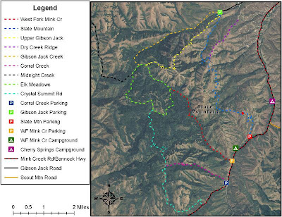
I found this map after I got back from the Slate Mountain hike. The red dot on the blue trail is where I think I got to on that attempt. Guesstimating from the map, I was maybe 1-1.5 miles of the way in, certainly no more than 2.
Here I've inverted the colors on the map, which I think makes it easier to read, and I've marked out the route that I took the time I got lost. I'm not sure where, exactly, I turned around on Crystal Summit Road. I got a ride partway back. Bare minimum estimate from the map: 12 miles - approx. 1 mile ride = 11 miles. It's a bit hard to judge switchbacks, etc, on a map this small, so it could certainly have been further than that. On the plus side, if I'd made it all the way down Crystal Summit Road, I probably would have had cell phone reception to call my mom to come get me, as I would have recognized Bannock County Highway when I got down to it.


No comments:
Post a Comment